Showing posts with label Greece. Show all posts

Jun 10, 2017

Mount Pelion | Greece


Last week my parents went to amazing Pelion, Greece, and they send me these two postcards. I can honestly say that the colour of the sea is exactly like that in real life! Pelion or Pelium (Modern Greek: Πήλιο, Pílio; Ancient Greek/Katharevousa: Πήλιον. Pēlion) is a mountain at the southeastern part of Thessaly in central Greece, forming a hook-like peninsula between the Pagasetic Gulf and the Aegean Sea.


In Greek mythology, Mount Pelion (which took its name from the mythical king Peleus, father of Achilles) was the homeland of Chiron the Centaur, tutor of many ancient Greek heroes, such as Jason, Achilles, Theseus and Heracles. It was in Mount Pelion, near Chiron's cave, that the marriage of Thetis and Peleus took place. The uninvited goddess Eris, to take revenge for having been kept outside the party, brought a golden apple with the inscription "To the Fairest". The dispute that then arose between the goddesses Hera, Aphrodite and Athena resulted in events leading to the Trojan War. When the twins Otus and Ephialtes attempted to storm Olympus, they piled Mount Pelion upon Mount Ossa (this is the origin of the idiom, to "pile Pelion on Ossa").


They used a 0,80 euro stamp picturing Aristotle.

May 20, 2017

Sifnos | Greece


This postcard is Sifnos (Greek: Σίφνος; the spelling Siphnos is obsolete in English but still by convention often used to refer to the island in ancient times), which is an island municipality in the Cyclades island group in Greece. The main town, near the center, known as Apollonia (pop. 869), is home of the island's folklore museum and library. The town's name is thought to come from an ancient temple of Apollo on the site of the church of Panayia Yeraniofora. The second-largest town is Artemonas (800), thought to be named after an ancient temple of Apollo's sister-goddess Artemis, located at the site of the church of Panayia Kokhi. The village of Kastro (118), was the capital of the island during ancient times until 1836. It is built on top of a high cliff on the island's east shore and today has extensive medieval remains and is the location of the island's archeological museum. The port settlement, on the west coast of the island is known as Kamares (245).

There are 360 churches in the island of Sifnos, more than any other island in Cyclades. It is no coincidence, the large number of festivals held on the island almost every month. Many churches and monasteries of the island are historical sites with great religious and architectural interest. The most important one is the monastery of Panagia Chryssopigi. One of the most "popular" churches of the island, is one of the Seven Martyrs, where many couples choose to get married. Still, Panagia Poulati renowned both for its beauty and what the landscape that surrounds it.

It was posted from Sifnos, but I cannot make out the date.

May 15, 2017

Nafplio | Greece

My parents visited Nafplio recently, one of the most picturesque Greek towns, and sent me these two beautiful postcards.


Nafplio (Modern Greek: Ναύπλιο) is a seaport town in the Peloponnese in Greece that has expanded up the hillsides near the north end of the Argolic Gulf. The town was an important seaport held under a succession of royal houses in the Middle Ages as part of the lordship of Argos and Nauplia, held initially by the de la Roche following the Fourth Crusade before coming under the Republic of Venice and, lastly, the Ottoman Empire. The town was the capital of the First Hellenic Republic and of the Kingdom of Greece, from the start of the Greek Revolution in 1821 until 1834. Nafplio is now the capital of the regional unit of Argolis.


The water castle of Bourtzi (Greek: Μπούρτζι, from Ottoman Turkish برج - burc meaning "tower"; formerly Καστέλι, Kasteli) is located in the middle of the harbour of Nafplio. The Venetians completed its fortification in 1473 to protect the city from pirates and invaders from the sea. The Greeks regained it from the Turks on June 18, 1822, from where they assisted in the siege of Nafplio. Until 1865 it served as a fortress. It was then transformed into residence of the executioners of convicts from the castle of Palamidi. From 1930 to 1970, it served as a hotel. Since then, it is mainly a tourist attraction hosting occasionally parts of the Summer Music Festival. [wikipedia]

May 7, 2017

Tilos | Greece


A couple of months ago, when I came home from work I had a pleasant surprise! A beloved friend has moved to Tilos island and sent me this beautiful postcard! She wrote that this is the view she has on her way to work (she teaches Greek to refugee children).

Tílos (Greek: Τήλος; ancient form: Telos) is a small Greek island and municipality located in the Aegean Sea. It is part of the Dodecanese group of islands, and lies midway between Kos and Rhodes. It has a population of 780 inhabitants (2011 census). Along with the uninhabited offshore islets of Antitilos and Gaidaros, it forms the Municipality of Tilos, which has a total land area of 64.525 square kilometres (24.913 sq mi). Tilos is part of the Rhodes regional unit.

Popularly, Telos was the son of Helios and Halia, the sister of the Telchines. He came to the island in search of herbs to heal his ill mother, and later returned to found a temple to Apollo and Neptune. However, Telos (Telo or Tilo) does not appear in Greek mythology and the name probably has an unknown pre-Hellenic origin. Pliny the Elder notes that in antiquity Telos was known as Agathussa (Αγαθούσσα) (also Agathusa and Agathousa). In the Middle Ages, it was known by the Italian as Episcopio, either because it was a Bishop Seat or because its position as Vantage Point. The island has also been called in Turkish İlyaki and in modern Italian Piscopi.


It was posted on 15 March 2017 and the stamp used pictures Aristotle. To mark the 2400th anniversary of the birth Aristotle, who was born in 384 BCE, Hellenic Post issued a commemorative set of stamps to honour his invaluable contribution to humanity. The works of the great Macedonian philosopher of antiquity, the student of Plato and the tutor of Alexander the Great, unique in range and influence in the history of human thought, are an integral and essential part of world cultural heritage.

This is the thinking behind UNESCO proclaiming 2016 “Aristotle Anniversary Year”, an initiative of the Interdisciplinary Centre for Aristotle Studies at the University of Thessaloniki, implemented by the Greek National Commission for UNESCO.

Oct 10, 2015

Planet Island | Greece


This is one of the postcards my parents sent me. It shows Planitis island near Tinos, Greece. Planitis  [Greek : Πλανήτης, which means planet] is an almost rocky Greek island with a dilapidated lighthouse on its summit. It is joined with Kavalurko beach by small rocks, which form small narrows, called Diapori connecting the bay with the open sea (Aegean Sea). On Planitis there used to be a marble mine, but nowadays one can meet only wild rabbits instead of miners.

The lighthouse first functioned in the year 1886. It marks the harbor of Panormos, the only harbor in the north –for this is also important for fishermen.The altitude of tower is 8 metres and the height of focal plane is 85 metres. 

Tinos Island | Greece

A few weeks ago my parents went to the beautiful island of Tinos in Greece and they sent me these postcards. They were mesmerized by the picturesque villages and the amazing beaches.

Tinos (Greek: Τήνος) is a Greek island situated in the Aegean Sea. It is located in the Cyclades archipelago. In antiquity, Tinos was also known as Ophiussa (from ophis, Greek for snake) and Hydroessa (from hydor, Greek for water). The closest islands are Andros, Delos, and Mykonos. It has a land area of approximately 194 square kilometres (75 sq mi) and a 2011 census population of 8,636 inhabitants.

Tinos is famous amongst Greeks for the Church of Panagia Evangelistria, its 80 or so windmills, about 1000 artistic dovecotes, 50 active villages and its Venetian fortifications at the mountain, Exomvourgo. On Tinos, both Greek Orthodox and Roman Catholic populations co-exist, and the island is also well known for its famous sculptors and painters, such as Nikolaos Gysis, Yannoulis Chalepas and Nikiforos Lytras.

The island is located near the geographical center of the Cyclades island complex, and because of the Panagia Evangelistria church, with its reputedly miraculous icon of Virgin Mary that it holds, Tinos is also the center of a yearly pilgrimage that takes place on the date of the Dormition of the Virgin Mary (15 August, "Dekapentavgoustos" in Greek). This is perhaps the most notable and still active yearly pilgrimage in the region of the eastern Mediterranean. Many pilgrims make their way the 800 metres from the ferry wharf to the church on their hands and knees as sign of devotion. [wikipedia]


Sep 20, 2015

Dervish Dancer in Salonica | Greece

Today I went to a car boot sale and had some amazing finds! My favorite one is this postcard of a Dervish Dancer in Salonica, Greece.


A dervish or darvesh (from Persian درویش, Darvīsh via Turkish, Somali: Daraawiish, Arabic: درويش‎, Darwīš) is someone treading a Sufi Muslim ascetic path or "Tariqah", known for their extreme poverty and austerity. His focus is on the universal values of love and service, deserting the illusions of ego to reach God. In most Sufi orders, a dervish is known to practice dhikr through physical exertions or religious practices to attain the ecstatic trance to reach Allah. [wikipedia]

The publisher of this postcard is Gilbert Baudinière, a french publisher who published postcards up until 1918, when he started publishing novels and poems. So this postcard was published 0n 1918 the latest.

Sep 19, 2015

Astypalaia | Greece


This postcard was sent by some very dear friends who traveled in the Greek island of Astypalaia, which means Old City in Greek. Astypalaia (Greek: Αστυπάλαια), called in Italian Stampalia and in Ottoman Turkish İstanbulya (استانبوليه), is a Greek island with 1,334 residents (2011 census). It belongs to the Dodecanese, an island group of twelve major islands in the southeastern Aegean Sea. The island is 18 kilometres (11 miles) long, 13 kilometres (8 miles) wide at the most, and covers an area of 97 km2. Along with numerous smaller uninhabited offshore islets (the largest of which are Sýrna and Ofidoussa), it forms the Municipality of Astypalaia. Astypalaia is part of the Kalymnos regional unit.

In Greek mythology, Astypalaia was a woman abducted by Poseidon in the form of a winged fish-tailed leopard. The island was colonized by Megara or possibly Epidaurus, and its governing system and buildings are known from numerous inscriptions. Pliny the Elder records that Rome accorded Astypalaia the status of a free state. [wikipedia]


Aug 14, 2015

Seagull islets | Greece

The only residents of these three islets are seagulls, hence the name Glaronissia [Greek: Γλαρονήσια, 'seagul islands']. They are located north of Papafragos Beach, in Milos island. The best way to come close to them is by boat from Adamadas village.

Milos, the island of 70 beaches | Greece


I must admit that Milos island is one of the most beautiful islands I have ever been. Beautiful beaches, amazing people. I wish I can visit it again soon.

Milos or Melos (Modern Greek: Μήλος; Ancient Greek: Μῆλος Melos) is a volcanic Greek island in the Aegean Sea, just north of the Sea of Crete. Milos is the southwesternmost island in the Cyclades group.
The island is famous for the statue of Aphrodite (the "Venus de Milo", now in the Louvre), and also for statues of the Greek god Asclepius (now in the British Museum) and the Poseidon and an archaic Apollo in Athens. The Municipality of Milos also includes the uninhabited offshore islands of Antimilos and Akradies. The combined land area is 160.147 square kilometres (61.833 sq mi) and the 2001 census population was 4,977 inhabitants.

There are about 70 beaches on Milos Island. Hivadolimni Beach is the longest at about 1 kilometre (0.62 mi). The rest of the beaches are starting from (North): Sarakiniko Beach, Papafragas, Kapros, Pachena, Alogomantra, Konstantinos, Mitakas, Mantrakia, Firopotamos, Nerodafni, Lakida, Plathiena, Fourkovouni, Areti, Pollonia, Gourado and Filakopi. (South): Firiplaka, Paliochori, Provatas, Tsigrado, Agia Kyriaki, Psaravolada, Kleftiko, Gerontas, Gerakas, Agios Sostis, Mouchlioti, Katergo, Spathi, Firligos, Pialothiafes, Kalamos, Krotiraki, Psathi, Svoronou and Sakelari. (West): Agios Ioannis, Cave of Sikia, Agathia, Triades and Ammoudaraki. (East): Voudia, Thalassa, Paliorema, Tria Pagidia and Thiafes. (In the Bay Area): Hivadolimni, Lagada, Papikinou, Fatourena, Klima, Skinopi and Patrikia. The North and South and bay beaches are tourist attractions. The east beaches are very quiet, and those to the west are also quiet beaches. [wikipedia]Glaronisia Beach Milos: Glaronisia is not a beach but a complex of islets that are found north of Milos, a bit off Papafragas beach. These islets can be seen by boat that makes the tour of the island. With a volcanic background, Glaronisia have interesting geology. Source: www.greeka.com
Glaronisia Beach Milos: Glaronisia is not a beach but a complex of islets that are found north of Milos, a bit off Papafragas beach. These islets can be seen by boat that makes the tour of the island. With a volcanic background, Glaronisia have interesting geology. Source: www.greeka.com

Jul 30, 2012

Andros island | Greece

Recently my uncle gave me his small collection of postcards that he had. Among them I found a dozen postcards from Andros, my favorite Greek island! Most of them seem really old.
 I think this is the oldest. It shows the interior of a house in Alikandros village.
 This second one is a multi view of Andros island.
 This one shows Saint Nicolas and the Navy Club.
And this one shows Theoskepasti and Paraporti Village.

Andros, or Andro (Greek: Άνδρος) is the northernmost island of the Greek Cyclades archipelago, approximately 10 km (6 mi) south east of Euboea, and about 3 km (2 mi) north of Tinos. It is nearly 40 km (25 mi) long, and its greatest breadth is 16 km (10 mi). Its surface is for the most part mountainous, with many fruitful and well-watered valleys. The area is 380 km2 (147 sq mi). The largest towns are Andros (town), Gávrio, Bátsi, and Órmos Korthíou.
The island is famous for its Sariza spring at Apoikia where the water comes out of a lionhead. Palaeopolis, the ancient capital, was built into a steep hillside, and its harbor's breakwater can still be seen underwater. [wikipedia]

As I have said before, Andros is the perfect place for vacations. There you will find the most beautiful beaches you have ever seen and the most hospitable people!

Sep 11, 2011

Monemvasia, Gibraltar of the East | Greece


Monemvasia is a unique place. It is a small island connected to the mainland via a narrow bridge. It is a perfect getaway for a weekend!

Monemvasia (Greek: Μονεμβασία) is a town and a municipality in Laconia, Greece. The town is located on a small peninsula off the east coast of the Peloponnese. The peninsula is linked to the mainland by a short causeway 200m in length. Its area consists mostly of a large plateau some 100 metres above sea level, up to 300 m wide and 1 km long, the site of a powerful medieval fortress. The town walls and many Byzantine churches remain from the medieval period. The seat of the municipality is the town Molaoi.
The town's name derives from two Greek words, mone and emvasia, meaning "single entrance". Its Italian form, Malvasia, gave its name to Malmsey wine. Monemvasia's nickname is the Gibraltar of the East or The Rock. [wikipedia]

Skiathos island

This vintage postcard shows Skiathos, a small Greek island

Skiathos (Greek: Σκιάθος, pronounced [sciˈaθos]; Latin forms: Sciathos and Sciathus) is a small Greek island in the northwest Aegean Sea. Skiathos is the westernmost island in the Northern Sporades group, east of the Pelion peninsula in Magnesia on the mainland, and west of the island of Skopelos.
In Ancient times, the island played a minor role during the Persian Wars. In 480 BC, the fleet of the Persian King Xerxes was hit by a storm and was badly damaged on the rocks of the Skiathos coast. Following this the Greek fleet blockaded the adjacent seas to prevent naval invasion and provisions for the enemy of 300 Spartans who stood heroically at Thermopylae pass. The Persian fleet was defeated there at Artemisium and finally destroyed at the Battle of Salamis a year later. Skiathos remained in the Delian League until it lost its independence. The city was destroyed by Philip V of Macedon in 200 BC.
In 1207 the Gyzi brothers captured the island and built the Bourtzi, a small Venetian-styled fortress similar to the Bourtzi in Nafplio, on an islet just out of Skiathos Town, to protect the capital from the pirates. But the Bourtzi was ineffective in protecting the population and in the mid-14th century the inhabitants moved the capital from the ancient site that lay where modern Skiathos Town is to Kastro (the Greek word for castle), located on a high rock, overlooking a steep cliff above the sea at the northernmost part of the island.
In 1704 monks from Athos built the Evangelistria monastery which played a part on the Greek War of Independence as a hide-out for Greek rebels. The first flag of Greece was created and hoisted in the Evangelistria monastery in Skiathos in 1807. Several prominent military leaders (including Theodoros Kolokotronis and Andreas Miaoulis) had gathered there for consultation concerning an uprising, and they were sworn to this flag by the local bishop.
After the War of Independence and demise of piracy in the Aegean, Kastro became less important as a strategic location. In 1830s, the island's capital was moved to the original site — where it still remains. Today, ruins of Kastro are one of tourist attractions.
During the 19th century Skiathos became an important shipbuilding centre in the Aegean due to the abundance of pine forests on the island. The pine woods of the island were then almost obliterated. This was brought to a halt though, due to the emergence of steamboats. A small shipwright remains north of Skiathos Town, which still builds traditional Greek caiques.
The film Mamma Mia was partially filmed on Skiathos and nearby island Skopelos. This has increased it's popularity as a tourist destination since the release of the successful movie. [wikipedia]

Breathtaking Mani

Another stop of my Summer vacations was Mani. I believe it is one of the most beautiful places in the world. I like it because it is always nice to be there throughout the year! Apart of the amazing scenery, it has very interesting architecture.

The Mani Peninsula (Μάνη in Greek), also long known as Maina or Maïna, is a geographical and cultural region in Greece. Mani is the central peninsula of the three which extend southwards from the Peloponnese in southern Greece. To the east is the Laconian Gulf, to the west the Messenian Gulf. The peninsula forms a continuation of the Taygetos mountain range, the western spine of the Peloponnese.
Mani is home of the Maniots. The terrain is mountainous and inaccessible. The name "Mani" is thought to have originally meant "dry" or "treeless." Until recent years many Mani villages could be reached only by sea. Today a narrow and winding road extends down the west coast from Kalamata to Areopoli, then south to Akrotainaro (the pointy cape which is the most southward soil of continental Greece and continental Europe) before it turns north until Gytheio.

Vatheia (Greek: Βαθειά, also Vathia) is a little town in Laconia, Greece, on the Mani Peninsula. It is part of the municipal unit Oitylo. It is famous for its grand towers (pyrgoi). The hills and mountains dominate the northern part, farmlands are within the valley areas, forests are rare and are only situated in and around the valley area. On the hilltops are abandoned homes, which are colored with earth and topaz along with its rooftops which are like fortresses and were built out of stone south of the place (plateia). Modern buildings exists in the centre. Now Vatheia is a tourist attraction in spring because of its wild flowers that cover the nearby hills and its breathtaking views. [wikipedia]

Macedonian women and Tsolias


Lately I'm started to get more and more interested in vintage postcards and especially the ones showing people and/or national costumes. The first postcard shows two Macedonian women in national costumes. 
Macedonians (Greek: Μακεδόνες, Makedónes) are a regional population group of ethnic Greeks, inhabiting or originating from the region of Macedonia, in northern Greece. They are largely concentrated in the capital city of Thessaloniki, but many have spread across the whole of Greece and in the diaspora.


The second postcard shows a man (Tsolias or Evzonas) dressed in Greek national costume. 
The Evzones, or Evzoni, (Greek: Εύζωνες, Εύζωνοι) is the name of several historical elite light infantry and mountain units of the Greek Army. Today, it refers to the members of the Proedriki Froura (Presidential Guard), an elite ceremonial unit that guards the Greek Tomb of the Unknown Soldier (Άγνωστος Στρατιώτης), the Hellenic Parliament and the Presidential Mansion. The Evzones are also known, colloquially, as Tsoliades (Greek: Τσολιάδες; singular: Τσολιάς - Tsolias).

Gytheio and Marathonisi


For my Summer vacations I went to a couple of Greek islands and me  and my husband made a small tour of Peloponnese. We stayed a couple of nights at Gytheion, a picturesque small town by the sea. 

Gytheion or Gytheio (Greek: Γύθειο) is located in middle south of Peloponnese at the center of the Laconian Gulf. It is a lively, charming little harbor town. The most of its houses are two- or three-storey neo-classical mansions, stuck to the steep side of the Mt. Koumaros. A long sea-side promenade, the colorful fishing boats, the narrow streets and stairways produce the typical Greek environment which fascinates every visitor.

There are not really mentionable ancient objects to be studied in Gytheio. From its ancient past only a small Roman theater was left by an earthquake that destroyed the city in the 4th century. So, every visitor is free to enjoy just Greek present life.

Gythio is protected by spurs of the mighty Taygetos mountain range. Its highest "Profitis Ilias", with 2.407 m the highest mountain on the whole Peloponnese, makes a marvelous background scene. From November to May, the snow-white peaks are a magnificent sight behind the deep blue sea.

Aug 28, 2011

Patmos island

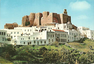
 This postcard was also found in that abandoned house. It shows Patmos island, but it is not used, so it doesn't have a date on it. I have never been to Patmos, but I have been told that it is one of the most beautiful Greek islands!

Patmos (Greek, Πάτμος; Italian: Patmo) is a small Greek island in the Aegean Sea. One of the northernmost islands of the Dodecanese complex, it has a population of 2,984 and an area of 34.05 km² (13 square miles). The highest point is Profitis Ilias, 269 meters above sea level. The Municipality of Patmos, which includes the offshore islands of Arkoi (pop. 54), Marathi (pop. 6), and several uninhabited islets, has a total population of 3,044 (2001 census) and a combined land area of 45.039 km². It is part of the Kalymnos peripheral unit.
Patmos' main communities are Chora (the capital city), and Skala, the only commercial port. Other settlements are Grikou and Kampos. The churches and communities on Patmos are of the Eastern Orthodox tradition. In 1999, the island's historic center Chora, along with the Monastery of Saint John the Theologian and the Cave of the Apocalypse, were declared World Heritage Sites by UNESCO. The monastery was founded by Saint Christodulos. Patmos is also home to the Patmian School, a notable Greek seminary.
Patmos is mentioned in the Christian scriptural Book of Revelation. The book's introduction states that its author, John, was on Patmos when he was given (and recorded) a vision from Jesus. Early Christian tradition identified this writer John of Patmos as John the Apostle, though some modern scholars are uncertain. As such, Patmos is a destination for Christian pilgrimage. Visitors can see the cave where John is said to have received his Revelation (the Cave of the Apocalypse), and several monasteries on the island are dedicated to Saint John.
According to a legend within the Greek mythology, the island's original name was "Letois," after the goddess Artemis, daughter of Leto. It was believed that Patmos came into existence thanks to her divine intervention. Mythology tells of how Patmos existed as an island at the bottom of the sea.
Deer-huntress Artemis frequently paid visits to Caria, the mainland across the shore from Patmos, where she had a shrine on Mount Latmos. There, she used to meet up with the moon goddess Selene, who cast her light on the ocean, revealing the sunken island of Patmos.
Selene was always trying to get Artemis to bring the sunken island to the surface and, hence, to life. Selene finally convinced Artemis, who, in turn, elicited her brother Apollo's help, in order to persuade Zeus to allow the island to arise from the sea.
Zeus agreed, and the island emerged from the water. The Sun dried up the land and brought life to it. Gradually, inhabitants from the surrounding areas, including Mount Latmos, settled on the island and named it "Letois" in honour of Artemis. [wikipedia]

Arta's Bridge (Το γεφύρι της Άρτας) "They built all day--each night it fell"


As I have mentioned before, I am an architect so I get to visit many old, abandoned houses. In one of these houses I found 10-15 old postcards. One of them is this one, which was sent on 25 February 1974. It shows the most famous old bridge in Greece, which is situated in Arta. It crosses the Arachthos river (Άραχθος). The bridge is famous because of an urban legend that is connected with its construction. It is said that every day 60 apprentices and 45 craftsmen, under the leadership of the Chief Engineer, tried to build the bridge, but its foundations would collapse every night. Finally a bird with a human voice informed the Chief Engineer that in order for the bridge to remain standing, he must sacrifice his wife. As the wife was being built in the foundations of the construction, she uttered curses that concluded with blessings.
Up until now, whenever someone crosses this Bridge, becomes silent and shy as a tribute to the wife of the Chief Engineer. The legend has it, that her sacrifice made the construction of the Bridge possible, reversing the curse into a wish for the generations to come. The Bridge finally connected the two riversides of Arahthos river. Apart from the physical connection of the river, this Bridge is also what connects Arta with its historical past, its living present and hopefully its future.

Aug 27, 2011

Mystras, the 'wonder of the Morea'

For my summer vacations me and my hubby went for a mini tour of Peloponesse (Southern Greece). One of the stops was at Mystras. I was amazed by the beauty of the place! No wonder it is a Unesco World Heritage Site!

Mystras, the 'wonder of the Morea', was built as an amphitheatre around the fortress erected in 1249 by the prince of Achaia, William of Villehardouin. Reconquered by the Byzantines, then occupied by the Turks and the Venetians, the city was abandoned in 1832, leaving only the breathtaking medieval ruins, standing in a beautiful landscape. The complex of the ruins of Mystras offers the image of a city with a brilliant destiny that was deserted by men and threatened by the return of encroaching vegetation, which is splitting the walls and covering the slopes, thus destroying here and there fragile traces of history.
Mystras came into existence in 1248-49 when the Frankish lord, William II of Villehardouin, Prince of Achaia, resolved to build a great castle on the top of the 620 m hill overlooking Sparta. The castle would be able to withstand attacks by the Byzantines, and also contain the Esclavons, the Slavic tribes of the Melinges and the Lezerites who inhabited the Taygete. Although a few inhabitants continued to live in the ruins, the city was not abandoned until after 1832, when King Otto I founded the new city of Sparta. For almost six centuries, Mystras lived a troubled existence. However, several times and under different regimes it assumed a leading political and cultural role. The vicissitudes of history did not spare the construction built by William II of Villehardouin. The castle had barely been completed when the Prince of Achaia, defeated by Michael VIII Palaeologus at the battle of Pelagonia and made prisoner, was forced to cede as ransom to the basileus the three strongholds of Monemvasia, Mania and Mystras (1261-62). When the favour of victory momentarily shined upon him once again, in 1265, Villehardouin found that the inhabitants of Sparta had deserted that vulnerable city and taken refuge around the castle of Mystras. From 1262 to 1348, because of many wars in which it was often the prize, Mystras was the seat of the Byzantine military governor, first named for a year then, after 1308, for life. The bishopric of Sparta was transferred to the new city, and the Metropolis, dedicated to St Demetrios, was built in 1264, and reconstructed after 1310. Convents, such as those of the Theodore Saints (prior to 196) and those of Brontochion (c. 1310) were built and richly decorated.

Aug 7, 2011

Ios


Ios (Greek: Ίος, locally Νιός - Nios) is a Greek island in the Cyclades group in the Aegean Sea. Ios is a hilly island with cliffs down to the sea on most sides, situated halfway between Naxos and Santorini. It is about 18 km (11 mi) long and 10 km (6 mi) wide, with an area of about 109 km² (42 mi²). Population was 1,838 in 2001 (down from 3,500 in the 19th century). Ios is part of the Santorini peripheral unit. Ios was the setting for the movie Ginger and Cinnamon (Dillo con parole mie). Also, scenes from the film Big Blue (Le Grand Bleu) were shot in Manganari.
The Port of Ios is at the head of the Ormos harbor in the northwest. From there the bus or a 15-minute walk up the steep donkey path takes you to the village, known as Chora. Chora is a white and very picturesque cycladic village, full of stairs and narrow paths, that makes it inaccessible for cars of any kind. Today, the main path through this village is completely taken over by tourism in terms of restaurants, boutiques, bars and discothèques. Apart from the port and the village of Chora, Ios has only a few small settlements, just a group of spread out houses in the background of major beaches (Theodoti, Kalamos, Maganari). Since the 1990s, the island mayor Pousseos has worked on Ios' development towards attracting different types of tourists. With the help of European Community funds some roads have been built, all of them paved, and a scenic amphitheater has been created by the German architect Peter Haupt (who died in 2003) at the top of the village hill. Unfortunately, cultural events rarely take place up there.
Excavations on Skarkos hill unearthed a prehistoric settlement, proving that Ios has been inhabited since the early Cycladic period. The architecture at Skarkos is preserved in places up to a height of almost three meters, with most of the buildings evidently having two storeys, stone-paved floors and a sewage system. Numerous well-preserved pottery, tools and utensils made of metal, stone and bone were also discovered. Unfortunately, the Skarkos site remains largely unpublished. In 2008, Ios was among six European locations (out of 109 candidates) awarded the European Union Cultural Heritage prize for its exceptional conservation efforts at the archaeological site of Skarkos.
During later times, Ios made rather few marks in history. According to ancient tradition, Homer's mother was from Ios, and he himself was buried there - and indeed the locals will show visitors the site of the ancient town of Plakotos at the northernmost end of the island, where the rocky entrance to a tomb may be seen. There is no physical evidence connecting this with Homer however. There are signs of Mycenaean settlement. The north end of Ios has a ruined Venetian castle from the 15th century. The island is said to have 365 churches and chapels, like the days of the year.
Ios attracts a large number of young tourists, many of whom used to sleep on their sleeping bags during the 1970s on the popular beach of Mylopotas after partying through the night. Today Mylopotas beach has been developed to an equivalent mass package tourism resort like Platys Gialos and Paradise Beach of Mykonos. [wikipedia]